When I left off on the first part of my Oregon Trail journey, my mom and I had decided to rest in Seward, Nebraska after two days of traveling. If this is the first post you’re reading, it might make more sense if you start here instead!

Day 3: Seward, NE to Laramie, WY (536 miles)
When we set off from Seward we were ready for some excitement. The journey had been monotonous up until that point, but we were prepared to change that. Since we were in Nebraska, we were in official Oregon Trail territory. We decided to make a few detours that day: first, we would stop in Gothenburg, NE, which was home to an original Pony Express station. Next, we would take a longer detour to see Chimney Rock and Courthouse Rock, which I remembered being landmarks in the Oregon Trail game. Our first stop in Gothenburg was relatively quick, but it was interesting to see this piece of US history. The Pony Express was once vital to communications between the east and west coasts, and records show it took about 10 days for messages to get from one end to the other. It’s amazing to see how far technology has come since then.

Next up were the Courthouse and Jail Rocks, which meant leaving I-80 for a while. To me this was a welcome change of scenery. The landscape changed; there were hills and rock formations and the Platte River in the distance. It was also desolate; we didn’t see many cars and the towns we passed through were tiny. After my GPS took us down a bumpy back road, we finally made it to the rocks just in time for it to start pouring rain. Then we moved on to Chimney Rock, which was only about a half hour drive away. It stopped raining by the time we got there, and we were the only car in the parking lot. The rock itself looked as I imagined it would, and I could see how early settlers would have been amazed at the sight. From a geological perspective I just didn’t understand how the rock could’ve formed, especially when it sat by itself amid the rest of the landscape.

After leaving Chimney Rock, our plan was to continue into Wyoming and find a place to rest for the night. As we pulled out of the parking lot, I made a comment about stopping for gas since we had just over half a tank left. Well. Because we were no longer on the interstate highway, we didn’t see many any gas stations. I thought that the Nebraska scenery in the morning was desolate, but that was nothing compared to the landscape we passed as we crossed into Wyoming on a random two-lane highway. What is more desolate than desolate? Bleak? Empty? All of those rolled into one then multiplied by ten? That’s what it was like. We saw no cars, no houses, no buildings… literally nothing. Every once in a while we would spot a random building off by itself in the distance, possibly a farmhouse or barn. But we couldn’t tell if these places were abandoned or not, and if they weren’t abandoned we had no idea where the people would buy groceries, supplies, or gas. Speaking of, we were getting closer and closer to that “E” on the dashboard. As someone who may or may not have run their car on fumes before, I knew based on the MPG and distance that we would make it to Cheyenne, WY before completely running out of gas, though it would be close. My mom was more concerned, which led to the most stressful hour of the entire trip. But we did make it to Cheyenne in time, which made us feel a lot better. We got back on I-80 to continue west, but we started to hit snow and decided to stop in Laramie, WY for the night. This was the most adventurous day for us so far, so we were ready to rest and relax.

Day 4: Laramie, WY to Burley, ID (619 miles)
We woke up to a few inches of snow on the ground, but luckily the snowfall was clearing up as we left Laramie. We were beginning our fourth day with another detour, though this one was my mom’s idea. We were going to Medicine Bow, WY- a town featured in the western TV series “The Virginian.” My parents sometimes watched the show, and when we had crossed into Wyoming my mom mentioned the town as one of the only places in the state she had heard of. When I saw how close it was to I-80, we decided to stop by. On the way there I was again amazed at the vast, emptiness of the land. Miles and miles of land stretched on either side of the two-lane highway, with hills and mountains sometimes visible in the distance. It was beautiful, but I couldn’t get over how little civilization there was.

Just outside of Medicine Bow itself, we stopped at a tourist attraction I had discovered online the night before: the Fossil Cabin. It was a building constructed of dinosaur bones! According to the website I found, the bones were taken from nearby Como Bluff, and the original owner had intended to display a whole dinosaur skeleton. When he realized he didn’t have enough bones to complete one, he decided to construct a building out of the fossils instead. The building was a highway tourist attraction until the completion of I-80 in 1970 diminished the number of travelers in the area. The property is currently for sale, but that didn’t prevent my mom and I from stopping to take a few pictures. After the Fossil Cabin, we continued into the tiny town of Medicine Bow itself. We didn’t actually stop the car, but we took a few photos as we drove through. My mom was surprised to see The Virginian Hotel; we think the TV series may have gotten its name from this hotel. After passing through the sleepy town we continued west, eventually joining up with I-80 again as we moved on toward Utah.
Wyoming was vast. It felt like it took forever to cross the state. There wasn’t much to look at along the highway, but the landscape was so different than the states we had passed through in the Midwest. This wasn’t farm land; it was ranch land. I know Montana is referred to as Big Sky Country, but that’s what Wyoming seemed like to me. It was the biggest sky that I’ve ever seen; my eyes were everywhere just trying to take it all in.

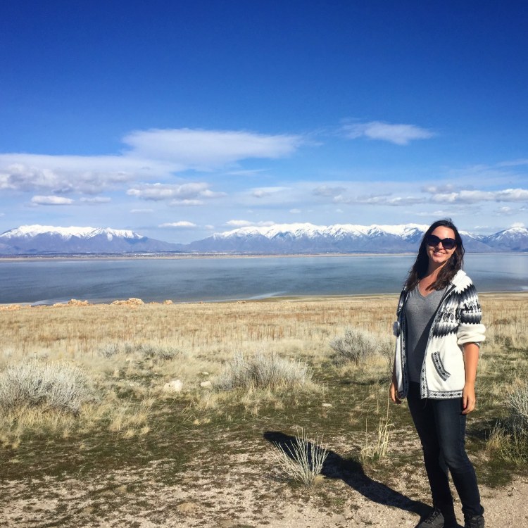
We eventually passed into Utah and the landscape changed to red, rocky cliffs and mountains. Sooner than I expected, we left I-80 for the last time and merged onto I-84, the highway that would eventually lead us into Portland. Since we were so close to Salt Lake City we decided to take another detour to see Great Salt Lake. I navigated us to Antelope Island State Park, a park that sits in the lake itself. I loved the view: it was a sunny day, so the water was bright blue and snowcapped mountains lined the sky in the distance. It was beautiful.
After leaving the lake and passing by the suburbs of Salt Lake City, we started to look for a place to stop for the night. Unfortunately, there wasn’t much of anything between the city and the Idaho state line. We had to drive for almost two hours more than planned because we didn’t pass a single lodging sign on the highway. We had expected to stay in Utah, but we crossed into Idaho in the evening and eventually made it to Burley, ID where we had a few hotels to choose from. It was a long day, but it was the best we had so far on the journey.
Day 5: Burley, ID to Portland, OR (586 miles)

On our fifth and final day I was so ready to hit the road and finish our journey to Portland. I was anxious to get out of the car and explore my new city. Because I was so excited most of Idaho was just a blur to me. I remember seeing Boise in the distance, but it didn’t even occur to me to take a picture. The first photo I snapped of the day was the “Welcome to Oregon” sign on the side of the highway.
The first thing that struck me as we crossed into Oregon was that the landscape was much browner than I expected. For the past two days I had been telling my mom how green Oregon was; it was one of the things that had blown me away when I visited Portland in the summer of 2017. However, the climate in eastern Oregon is very different than the western part of the state. The majority of eastern Oregon is considered high desert and remains fairly arid during most of the year. When I visited in 2017, I stayed in the western part of the state and never went east of Mount Hood. The climate in that region is very wet for most of the year, leading to the dense, lush forests that impressed me during my trip.

Sometime after lunch I-84 started to travel alongside the Columbia River and we entered the Columbia River Gorge Scenic Area. Due to the devastation from the Eagle Creek fire in the fall of 2017 we couldn’t travel on the smaller scenic highway, but it was still beautiful to drive close to the river. It was a sunny day and the water sparkled against a blue sky. I felt a little thrill every time we saw a sign declaring the miles left until Portland, the number getting smaller and smaller as we drove.
Eventually the interstate pulled away from the river and grew wider as more lanes joined in each direction. The road became more congested as we approached the city, and I kept my eyes peeled for the first sign of the city itself. And then there it was! The buildings of downtown Portland lined the river on the opposite shore, bridges spanned the water, and green hills rose up behind the city. In what felt like a blink of an eye, we were crossing one of the bridges and parking next to a hotel in downtown. Five days and over 2,600 miles later, our Oregon Trail journey had ended.

My westward journey was very different than what I had expected when I started planning the road trip weeks earlier. I had never been to most of the states we drove through, so I didn’t have any clue as to what to expect. As I walked around my new city that first night, I wondered what my new life would be like and what kind of adventures I would have. I had more questions than answers and no way of figuring anything out. What struck me was that even though technology had made my journey faster, safer, easier, and more enjoyable, the original Oregon Trail travelers would have had the same kinds of questions and worries. It was oddly comforting to think that people had been moving and migrating for decades; if they could do it in the 1800’s then I could do it in the 21st century. With that in mind, I promised myself to embrace new opportunities and to stay open to new people and surroundings. My Oregon Trail journey had ended, but my next adventure was already starting.
Have you ever moved across the country, or world? Have you ever been on a long road trip? What was your experience like?

katiegirl06460
I don’t think I would move at this late stage in life but I should would love to do a cross country ride. Sometimes I think about doing it by train but realized I would miss things…
LikeLike
Stories from Someplace
The little bit that I saw was incredible, I just wish I had more time to stop and really see the country. I never thought of doing it by train, I think that would be interesting!
LikeLike
katiegirl06460
I agree..:) but a tad expensive.
LikeLike